


Weld 101, Weld County, Colorado
About
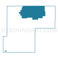
Outline

Summary
| Unique Area Identifier | 549394 |
| Name | Weld 101 |
| County | Weld County |
| State | Colorado |
| Area (square miles) | 628.37 |
| Land Area (square miles) | 628.13 |
| Water Area (square miles) | 0.24 |
| % of Land Area | 99.96 |
| % of Water Area | 0.04 |
| Latitude of the Internal Point | 40.85700360 |
| Longtitude of the Internal Point | -104.18857210 |
Maps


Graphs
Select a template below for downloading or customizing gragh for Weld 101, Weld County, Colorado


Neighbors
Neighoring Voting District (by Name) Neighboring Voting District on the Map
- Bushnell Precinct, Kimball County, NE
- CARPENTER FIRE STATION Voting District, Laramie County, WY
- PINE BLUFFS COMMUNITY CENTER Voting District, Laramie County, WY
- Weld 100, Weld County, CO
- Weld 102, Weld County, CO
- Weld 103, Weld County, CO
Top 10 Neighboring County Subdivision (by Population) Neighboring County Subdivision on the Map
- Cheyenne East CCD, Laramie County, WY (8,642)
- Ault CCD, Weld County, CO (6,601)
- Pine Bluffs CCD, Laramie County, WY (3,379)
- Raymer CCD, Weld County, CO (653)
- Grover CCD, Weld County, CO (521)
- Bushnell precinct, Kimball County, NE (303)
Top 10 Neighboring Place (by Population) Neighboring Place on the Map
Top 10 Neighboring Unified School District (by Population) Neighboring Unified School District on the Map
- Eaton School District RE-2, CO (9,648)
- Ault-Highland School District RE-9, CO (5,588)
- Laramie County School District 2, WY (5,540)
- Kimball Public Schools, NE (3,423)
- Briggsdale School District RE-10, CO (615)
- Pawnee School District RE-12, CO (522)
- Prairie School District RE-11, CO (393)
Top 10 Neighboring State Legislative District Lower Chamber (by Population) Neighboring State Legislative District Lower Chamber on the Map
Top 10 Neighboring State Legislative District Upper Chamber (by Population) Neighboring State Legislative District Upper Chamber on the Map
- State Senate District 13, CO (159,077)
- State Senate District 47, NE (32,377)
- State Senate District 6, WY (19,877)
Top 10 Neighboring 111th Congressional District (by Population) Neighboring 111th Congressional District on the Map
- Congressional District 4, CO (725,041)
- Congressional District (at Large), WY (563,626)
- Congressional District 3, NE (561,378)
Top 10 Neighboring Census Tract (by Population) Neighboring Census Tract on the Map
- Census Tract 20, Laramie County, WY (7,130)
- Census Tract 25.01, Weld County, CO (4,843)
- Census Tract 9545, Kimball County, NE (3,821)
Top 10 Neighboring 5-Digit ZIP Code Tabulation Area (by Population) Neighboring 5-Digit ZIP Code Tabulation Area on the Map
- 80610, CO (2,791)
- 82082, WY (1,606)
- 80648, CO (1,001)
- 82054, WY (920)
- 80611, CO (659)
- 80729, CO (540)
- 69128, NE (302)
- 80742, CO (225)